
Oregon’s South Coast region!
We hope our guidebooks will inspire you to explore Oregon’s beautiful South Coast region, and that’s why we try to keep them current. We’ve driven, hiked, biked or paddled all the places discussed in our books, and revisit them often.
As with every part of life, the passage of time brings changes. This applies to the outdoor recreation scene as well. Some changes are positive, such as new trails to hike, bike and paddle. Other times the news isn’t so good. Budget pressures, damage from storms or fires, and vandalism take their toll. This page will provide a few updates.
First,
though, a word of caution about signage in the back country. Sadly,
it’s getting worse. Shrinking budgets for maintenance is the
official answer, but vandals, souvenir hunters and target shooters
wage a relentless siege. That’s why it’s important
to use the
mileages and other information in the books.
And keep your wits
about you. Also keep in mind GPS units can’t always get a
signal in
steep canyons and other places, so using your odometer and the
mileages in the books can be the best plan.
Road
Closures
This
is an ongoing issue, which is why you should always check local
conditions before traveling too far afield. It’s much easier
to
just make a few phone calls than to drive for miles and hours only to
encounter a “Road Closed” sign. So . . . check with
whatever
agency is in charge of the place you want to travel, such as the
Bureau of Land Management, US Forest Service (Oregon Dunes National
Recreation Area, Rogue River-Siskiyou National Forest, Siuslaw
National Forest), Oregon State Parks, and county parks, etc. The
numbers are listed in the back of all our guidebooks.
Recreation
closures
Budget
cutbacks and weather-related damages have caused the Bureau of Land
Management to make some changes. The most significant is the
temporary closure of the popular Loon Lake campground, which took
some hard hits in a 2019 winter snowstorm. The BLM hopes to reopen it
for the 2020 season. The East Shore BLM campground and day-use site
remains open, as does the privately-run Loon Lake Resort. The BLM has
permanently closed the Burnt Mountain campground in the vicinity of
the Doerner Fir, although it remains available for “dispersed
camping,” which means no amenities. Also permanently closed
as the
Forest Giant day-use site which was mentioned in earlier editions of
“Out Our Back Door.”
Some
of the free BLM campgrounds that were open year round are now only
open seasonally, so that would be another thing to check before you
head out go camping.
New
fees
Budget
crunches have also forced agencies to raise fees, or to impose fees
where none existed previously, such as Coos County’s LaVerne
County
Park. Day-use had previously been free, but now an entry fee is
required. Like everyplace else, campground fees in this region go up
nearly every year.
Lookout and other recreation rentals
Among the many popular pastimes discussed in “Out Our Back Door” is the availability of former US Forest Service fire lookout towers and other sites for overnight rentals (page 176). The website that will help you make reservations has been changed to: https://www.fs.usda.gov/detail/r6/recreation/?cid=stelprdb5290342#rrs .
As
discussed in the guidebook, this is a fantastic experience.
South Coast Striders hiking group
In
other news, interest in the outdoors has spurred greater
participation in the South Coast Striders local hiking group, which
hosts twice-monthly (and sometimes more) hikes. They almost always
offer options for a long and short version of the hikes, which are
guided by locals familiar with the terrain. Get more information and
see the schedule at www.coostrails.com.
They also have a Facebook page (South Coast Striders).
“Out Our Back Door” Driving tours and Day-hikes Updates
Humbug Mountain trail
One common complaint about many scenic viewpoints is that they’re getting grown in with trees and brush. This is mentioned several times about places in “Out Our Back Door,” but we’re pleased to report that one place – Humbug Mountain south of Port Orford – has been selectively cleared of trees in a couple of places to restore views. All the directions, details and map in “Out Our Back Door” (page 155) remains accurate, there’s just some views where there hadn’t been for quite a while!
Riley
Ranch County Park in Hauser now offers direct vehicle and hiker
access to the Oregon Dunes National Recreation Area via a new sand
road that includes a bridge over the railroad tracks. It’s
more
popular with ATVers than hikers, though. So if you’re
interested in
more of a “walking experience,” try the Dellenback
Dunes trail
near Lakeside, which goes into a vehicle-free part of the dunes.
Canoe
and Kayak Updates
Butterfield
Lake: With the opening of Coos County’s Riley Ranch County
Park in
Hauser, a new place to paddle was made available to the public.
Butterfield Lake is a pretty little 20-acre body of water with about
two miles of forested shoreline. It was in private hands for many
years so hasn’t had many visitors, and there’s been
no
introduction of the invasive waterweed hydrilla.
Once you’ve
paddled the main body of water, head to the west toward a railroad
trestle. Floating logs may partially block the way, but
there’s
usually just enough water in a narrow channel to get into the western
portion of the lake, which is beautiful. You can paddle north a
little ways until floating logs get too dense. The deep dark water
around the logs might look promising to anglers.
Coquille River Water Trail
The Coquille River is one of several South Coast rivers that’s been getting attention lately for its paddling potential. The prospect of developing some more paddler amenities is being discussed by a coalition of enthusiastic citizens, watershed agencies, Port of Bandon representatives, parks officials, tribal members and others, with support from Travel Oregon, the state’s travel and tourism agency. A map/brochure for the Coquille River is in the works, hopefully to be followed by similar ones for the Umpqua, Coos, Rogue and Chetco rivers. The group has had several well-attended group paddles, and more will be considered for the 2020 season. The best way to stay informed is via the group’s Facebook page: Coquille River Water Trail.
The first of what’s envisioned as several launch ramps designed specifically for paddlers was installed in 2019 on the docks in Old Town Bandon. Others are planned for the Coos Estuary. As noted in “Oregon South Coast Canoe, Kayak and Stand-up Paddle Guide,” there’s an ongoing discussion about possibly creating a launch adjacent to the Coos History Museum along the Coos Bay waterfront.
Group paddle events in the Coos Bay Estuary have also been popular. The best attended is the annual Stand Up! For the Bay event in September, in conjunction with National Estuaries Week. The local Surfrider Foundation chapter is one of the main sponsors, and they’ve also been involved in group paddles, movie festivals and other activities in Coos Bay. Their web and Facebook pages are the best places to see what’s coming up.
Oregon South Coast Bicycle Ride Guide
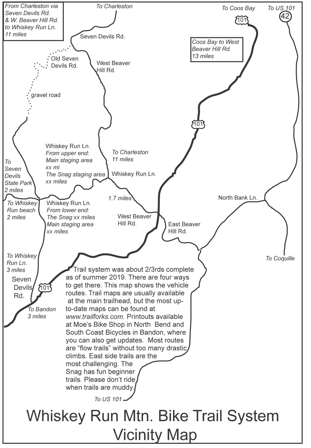
Perhaps the most exciting update is the creation of the Whiskey Run Mountain Bike Trail System on county forestlands between Coos Bay and Bandon. At this writing in late 2019, about two-thirds of what’s planned to be a 30-mile trail system has been completed. Trail maps are available at South Coast Bicycle in Bandon and Moe’s Bikes in North Bend. The best online map that reflects the latest conditions is at www.trailforks.com. Unfortunately, the trail system was created after the publication of our guidebook “Oregon South Coast Bicycle Ride Guide, so it’s not included. There are several ways to get to the trail system. Here’s a vicinity map:
Please let us know if you have any comments, corrections or suggestions. We appreciate hearing your feedback. Send an e-mail to westways@frontier.com or text or call 541.294.1112. Thanks again!
- Tom Baake, publisher
back to top
2 Guidebooks
for Just
$20
includes shipping
3 Guidebooks
for Just
$30
includes shipping